Tree Information
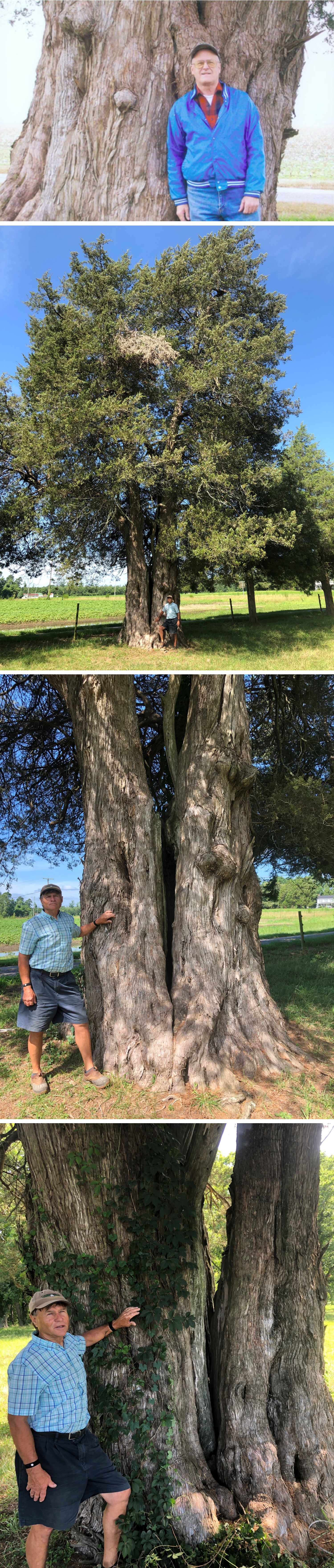
Common Name: eastern redcedar
Scientific Name: Juniperus virginiana var. virginiana
Native/Naturalized: Native to Virginia
Database ID: 236
Status: alive
National Champion: no
Virginia Champion: yes
Circumference: 223 in.
Height: 60 ft.
Crown: 57 ft.
Points: 297
Date Last Measured: 2021
Last Measured by: Byron Carmean and Gary Williamson
Date First Measured: 1986
Comments:
2021 comments: Tree is located on Wiggins 4-J Farm, a ""Virginia Century Farm"", circa 1750. Originally nominated in 1986 and was national champion until 1989 when it was dethroned by the current national champion in Georgia. Was renominated to Virginia Big Trees in 2005. Tree has co-dominant leaders that were fused and grafted to one another at time of original nomination, and the common girth of the two leaders was measured at that time. Since then, weather and crown mass have split the two leaders back apart and they now have an air gap between them that starts at height of 5' above ground. The bark inclusion between the stems extends down to ground line. It is difficult to surmise whether this is a tree from a single seed. The stems are of equal girth, height, and spread, which suggests a single seedling was damaged early in life and produced two leaders. Given its location in an ancient fence row, it may have been cut back as a seedling during fence maintenance long ago. At 4.5 feet, the tape wrap around both stems was 242". Each stem measured individually at this height was 132" and 180". The composite circumference of these stems is 223".
2009 comments: Tree was previously measured at 224", 68', 49', and 304 points by Byron Carmean and Gary Williamson.
2005 comments: Tree was previously measured at 218", 60', 52', and 291 points by Byron Carmean and Gary Williamson.
1986 comments: Tree was previously measured at 190", 62', 56', and 266 points by Byron Carmean and Gary Williamson.
More Photos
Location of Tree
Tree is located in: Southampton
Land Owner: Joe Nye Wiggins
GPS Coordinates: 36.607156, -76.930937
Directions: Route 258, south of junction with route 189.
Owner Address: 30149 Smiths Ferry Rd
Franklin, VA 23851
Owner Phone: 757-562-6189
Contact Information
Contact Name: Byron Carmean
Contact Email: rockplantrn@gmail.com
Contact Address: 3616 Labrador Ln.
Suffolk, VA 23434
Contact Phone: 757-934-0588
Nominators
Original Nominator(s): Byron Carmean and Gary Williamson
Additional Information
Our Partners